Hiking suggestions in Kvitfjell
Along the Peer Gynt trail there are many opportunities for short to long hikes, if you do not want to try the whole hike, which is 90 km.
See hiking trails and maps here
Drink water from Olavskilden, which is said to have healing power, enjoy great nature, silence and views of Gudbrandsdalslågen, Rondane and not least Kvitfjell ski resort's trail network. Take advantage of fishing opportunities or take a fresh swim in Gompen or in Svarttjønnet.
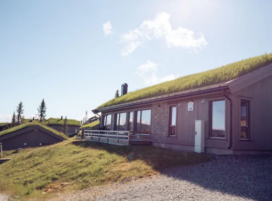
We have a sports shop open in the summer at Skitorget, and the popular Tyrihanstunet is open Wednesday-Saturday throughout July and August. Here you can enjoy a better lunch and good drinks before after a great mountain hike. The west side offers great hiking trails with access to Peer Gynt's kingdom.

The Peer Gynt Trail
The model for Ibsen's Peer Gynt was a real person who has lived in the Sødorp village near Vinstra. He has given his name to the mountain area that stretches from Gausdal and Skeikampen in the south to Skåbu and Espedalen in the north and west. Through this beautiful and varied mountain terrain runs the approximately 90 km long Peer Gynt trail.
You can read more about this on the Norwegian Trekking Association's website:

The Peer Gynt trail from Kvitfjell
Kvitfjell is connected to the Peer Gynt trail and the Norwegian Trekking Association's trail network with T-marked trails. These are also called the Peer Gynt trail.
The Peer Gynt trail starts from the parking area at Gudbrandsgard hotel and the path towards Skeikampen goes via Skardbua. It follows the service road in the ski resort southwest up the hillside. The trail goes on the east side of Kvitfjellet itself and over to the west side, where it follows the road up to Veslesetra. At Skardbua, the Peer Gynt trail is marked both towards Skeikampen and Fagerhøi.
The path towards Espedalen follows the ski trail to the northwest. It goes along Hestknappen and on to Svinslåa, Vendalen and Fagerhøi.

The pole hunt
Poles have been set up in Kvitfjell and the surrounding area, which will be in operation from 18 June. The poles can be registered both manually, digitally and by downloading an app on your mobile phone, so that you can scan the QR code that each pole is equipped with.

The waterfall at the middle station
Follow the path downhill from Gudbrandsgard Hyttegrend. After a few hundred meters, you hear the sound of a cascading waterfall. From there, turn right, it's a short and easy hike. The waterfall is idyllically beautiful, and it is possible to take a fresh shower here.
Legend has it that you will then remain eternally young, as the waterfall has holy water from St. Olav's spring.

Kvitfjellet
Kvitfjellet is the very hallmark of the area and a nice summit hike. Access is facilitated from the top station of the chairlift. There is a clear path to the west and the summit can be reached either via a steep path on the east side, or an easier path from the north side of the peak. Kvitfjellet is 1044 m high. The top of Kvitfjellet has a view of the whole of Kvitfjell, both the west side, the middle station and Varden as well as to Rondane and Jotunheimen. Kvitfjellet is also part of the pole hunt.

Olav's Fountain
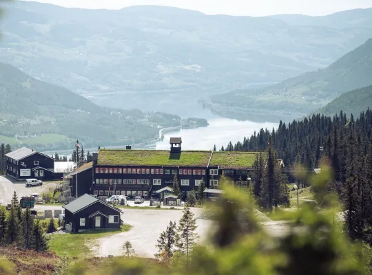
The Olav Spring can be found at the middle station near Gudbrandsgard Hotel, where you can drink fresh water straight from the spring, which is said to have healing powers. It will be particularly powerful on Thursday night. Several people throw a coin into Olav's spring to get a wish fulfilled.

Bånseterkampen
You can reach this fine rock formation via Myrsetra or via Skardbua/Svartvann. There are good paths along the edge of the top and the view south is impeccable.
From Bånseterkampen you can walk 3 km further and get to Prestkampen, or walk down to Svartvann and to Skardbua. You will also get to Skeikampen if you continue past Prestkampen from here.
Skardbua
On the way to Svartvann you will find Skardbua, which can be a nice hiking destination even in the summer.
The priest fight
This is the highest mountain in the immediate area at 1244 m. Prestkampen is located within Svartvann and can be reached via Bånseterkampen or Skardbua.

svartvann
Svartvann is located between Varden and Prestkampen and is especially nice in the summer with nice swimming opportunities.
There are several roads to Svartvann.
You can start on Dalavegen at Vesleseter, on Storslettbakken or Myrsetra.

hestknappen
The 1023 m horse button can be seen from the top station of the chairlift.
It is located northwest of Kvitfjellet and is characterized by being steep and narrow.
Access can take place from several sides. From the top station via clear paths in the terrain.
You can also walk up near the Gammelseter field by following the road uphill. There is also a clearly visible path from Svinslåvegen, where there are signs showing the starting point.

varden
The summit of Varden is located at 990 m. Here is a great area with many places where it is nice for a break with a lunch and thermos. There are marked separate paths that form a round trip from the top station on the chairlift and via Myrsetra.
If you come by car, there is a large parking lot at Storslettbakken. From there, walk the road to Myrsetra and up or walk from Varden where the path starts right by the chairlift. The trails are marked with orange markers.

Høgkleiva and Ringebu Stave Church
Enjoy great views towards Kvitfjell and south in Gudbrandsdalen from Høgkleiva in Ringebu. The trip can be started at the beautiful Ringebu Stave Church, so here you can kill several birds with one stone. Here there is a cozy souvenir shop and kiosk.
Follow signs for Kongsvegen southwards. The trip starts on a gravel road and continues on a path towards Høgkleiva. Continue towards the lookout point. Enjoy the view of the view and your packed lunch to the nice view or in the shelter nearby.

The plane wreck on Ringebufjellet
In October 1942, the plane was on its way from Fornebu to Banak via Værnes, when it froze down and an emergency landing was made inside the mountain. Today, the plane wreck still lies as a reminder of the incident, and it has become an exciting hiking destination for young and old.
Photo: Gunnar V. Aasbø-Skinderhaug

Segelstadseterkampen
This peak of 1022 m is easiest to reach from the top station of the chairlift. The peak is located to the east and there are several paths in the terrain that lead to the top.